
“What’s the range of the ICON A5?”
Of all the questions we get asked at ICON Aircraft, the above might be the one we receive most often.
Looking at the ICON A5, it doesn’t exactly scream cross-country machine. But many pilots and non-pilots are surprised to learn that the A5 has a range of 421 nautical miles, not as much as many traditional aircraft, but enough to fly reliably across many U.S. states and regions.
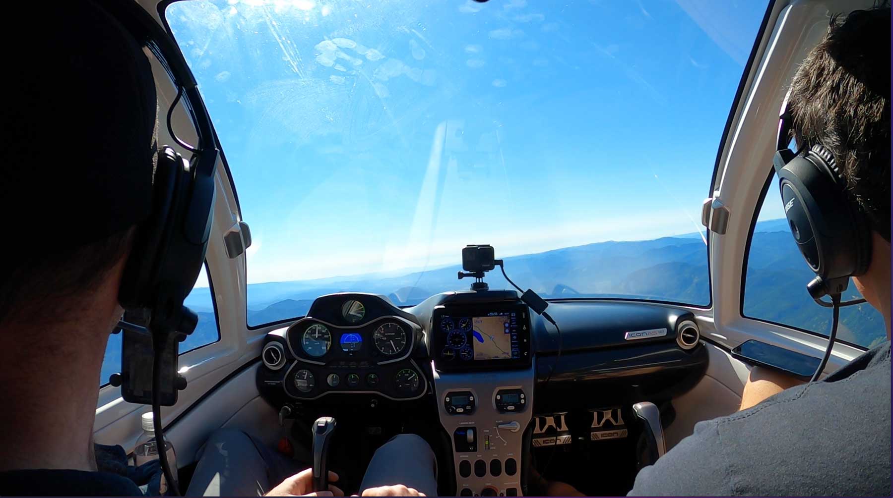
That said, the cockpit of the A5 is ergonomically designed with a very comfortable seat and with the stick in the middle, offering your body some relief. A canopy with seemingly endless visibility also allows for the trip to be more enjoyable and to enjoy the scenery around you.
With sales representatives and training locations on both coasts of the United States, including Seattle, it’s very common for the ICON Team to travel on cross-country flights to reach new, potential A5 customers. On a recent cross-country flight, I flew with ICON’s West Coast Regional Sales Director, Alex Mason, from Renton Airport in Seattle to Felts Field in Spokane, WA. Our objectives were to continue to connect with the aviation community in the PNW, and to allow seaplane pilots—current and aspiring—to understand why the ICON A5 was seemingly created for Eastern Washington and Northern Idaho.
The following is what Alex and I considered in planning our 230 Nautical Mile flight across the state of Washington. A modest flight, but one that hopefully presents the capabilities of the ICON A5 in a better light.
What cruise speed should you target on a cross-country in the A5?
Understanding the optimal cruise speed for your aircraft can shave hours off your cross-country’s final time while keeping excess fuel burn to a minimum. Many pilots are likely familiar with the Carson Number, whether they know it or not. The Carson Number is the optimal airspeed that trades a slightly higher fuel burn for a faster travel time. Basically, the Carson Number is the most efficient method of saving travel time while not burning more fuel than is needed.
The below table lists the time and fuel flow resulting from a range of ICON A5 airspeeds. The Carson Number on the A5 is, for all intents and purposes, 80 knots. Flying at 80 knots will allow the A5 to travel approximately 3 hrs and 8 minutes at 3/4 of a full tank (~15 gallons).
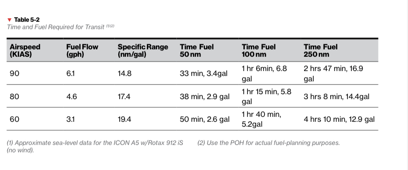
If one were to be very fuel conscious and fly at, say, 60 knots, this would save about 1.5 gallons of gas, but result in an additional hour of flight time.
Is a gallon and a half of gas worth an extra hour of time? Probably not.
Conversely, flying at 90 knots will burn an additional 2.5 gallons of gas compared to flying at 80 knots. An airspeed of 90 knots will save “only” 20 minutes of flight time, however.
Is burning an additional two and a half gallons of gas worth saving 20 minutes? Probably not.
Ergo, cruising at an indicated airspeed of 80 knots represents a viable option for favoring time over fuel consumption, without causing an unnecessary fuel burn.
Which altitude to fly on your cross country?
Most everyone reading this is likely aware of “cruising altitudes”. As a refresher, aircraft flying above 3000ft AGL in the U.S.:
- Must fly on an odd thousand + 500 when on an East heading (0-179 degrees)
- Must fly on an even thousand +500 heading when flying West (180-359 degrees)
We were flying east, which left us with 3500, 5500, 7500, 9500, etc. as possible altitude options.
What factors primarily shaped our decision at which of these altitudes to fly?
- Airspace (Class B, C, D shelves)
- Restricted or Prohibited Airspace
- Terrain (MEF)
- Winds Aloft
- Turbulence
- Weather/Cloud Clearance
In respect to our trip, we had to consider the Bravo shelf underlying Seattle’s airspace. This prevented a climb above 3000 ft, 5000 ft, and then finally 6000ft as we moved east.
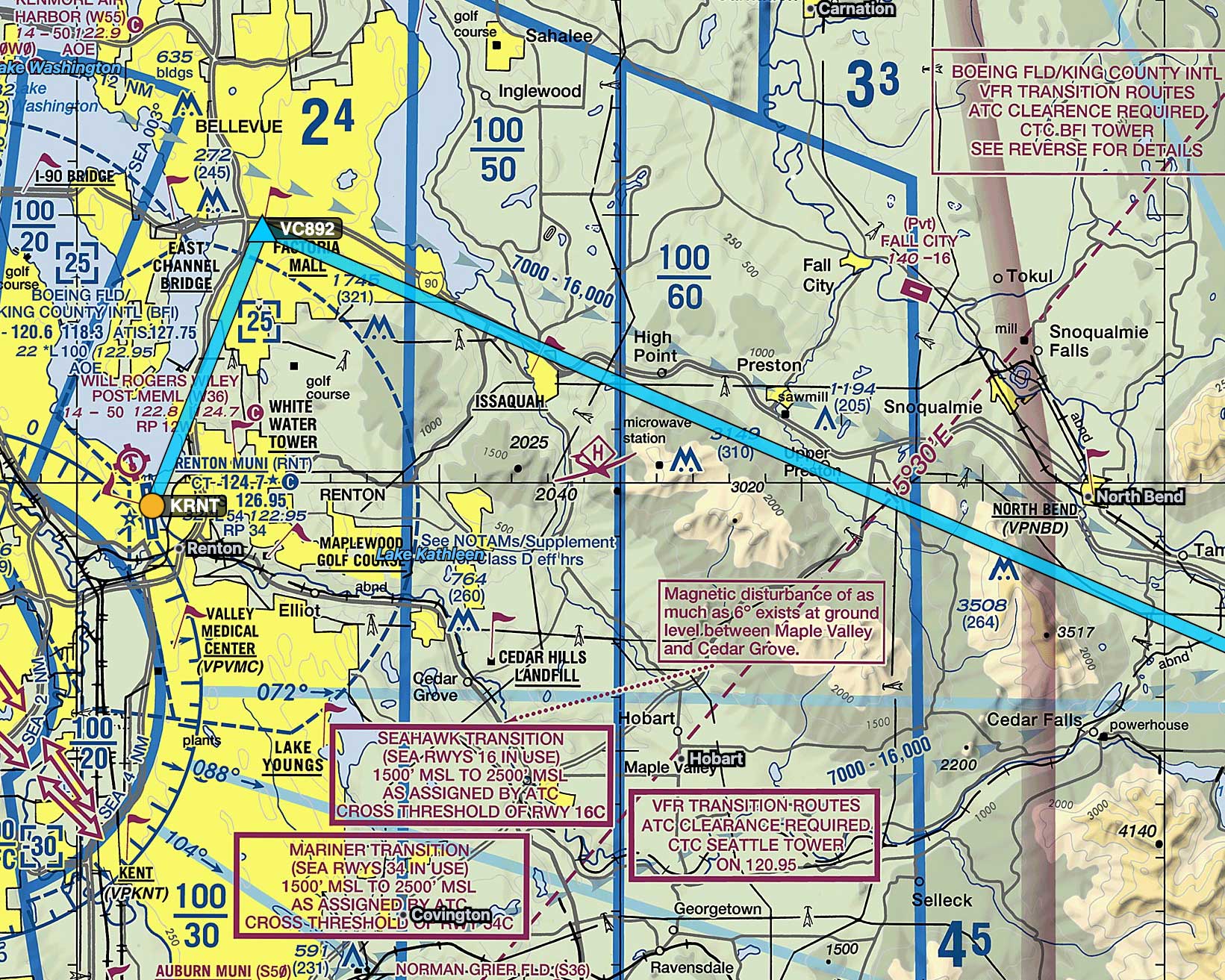
Flying across Washington required us to consider terrain i.e. the Cascade Mountain range. The I-90 traverses across the state and offers a good VFR route to travel in case we needed to use that as an out in an emergency. The interstate also traverses through lower elevations. Looking at the sectional, the pass shows an elevation of 3000 ft. The MEF (Maximum Elevation Figure) is as high as 7900 for some of these quadrants, but we’re not going to be flying over these mountain peaks and have visibility to avoid these clearances, so we chose to fly at 7500 ft.
Below, here is what the sectional chart looks like “in real life” at 7500 ft, with a view to the north.
With a roughly 4 knot tailwind at 5500ft and a 7 knot tailwind at 7500ft, there wasn’t a tremendous difference in the winds aloft. This factor did not influence our decision to fly higher.
In addition, it was a calm morning and there was little to no turbulence during this leg of the flight, thus we didn’t need to climb up to avoid any bumps or descend to battle any arduous winds.
Finally, the visibility was clear in a million. There were no clouds or fires in the area and we were able to see probably 40-50 miles, which removed the risk of flying into IMC conditions.
Flying into a new airport for the first time (Grant County)
During a cross-country flight to a new destination, it’s highly likely that pilots will encounter an airport with operating procedures that differ from what they may be accustomed to. This may not be a big deal for a confident pilot, nor should it necessarily be, but going into a new environment can have its challenges.
Flying into a new airport might require you to proceed with additional instructions you’re not accustomed to, which can cause more routine procedures to become ignored (lowering the flaps or gear, doing a proper go-around procedure if need be, etc.)
In this regard, the main advantage A5 pilots have when flying into a new, unfamiliar airport is two fold:
- Angle of Attack Indicator
- Visibility
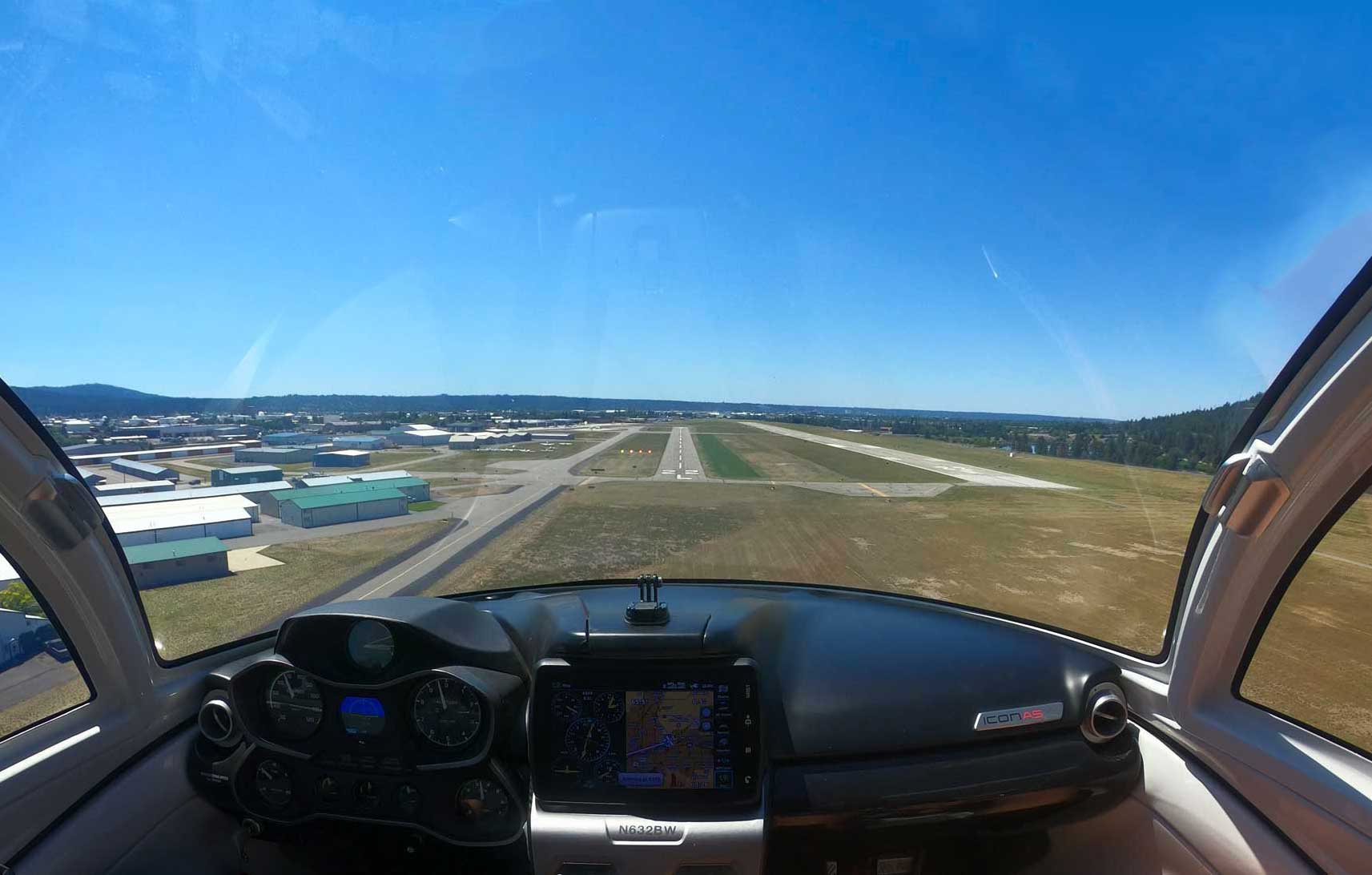
The Angle of Attack indicator replaces airspeed when it comes to configuring for downwind, final, and when crossing the gate on the runway. Instead of fixating on airspeed, the pilot can set the power to 3000 rpm, and from there, focus on the energy state of the wing by monitoring the angle of attack indicator. This practically eliminates the possibility of going into a spin on turning base to final and can greatly help with the touch down flare.
Scanning for traffic in a new environment is also imperative, as pilots might not be familiar with a particular airports pattern procedures. Most mid-air collisions happen in the traffic pattern when conditions are clear. Many of these collisions are the result of a lack of visibility from the plane cockpit. For instance, aircraft with high wings that can’t see the traffic above them and lower-wing aircraft that can’t see below. With the A5’s wings positioned aft of the cockpit, the ICON A5 has incredible visibility below and to the rear of the aircraft. To say nothing of the visibility from the front of the cockpit, which you can get a sense of from the image below.
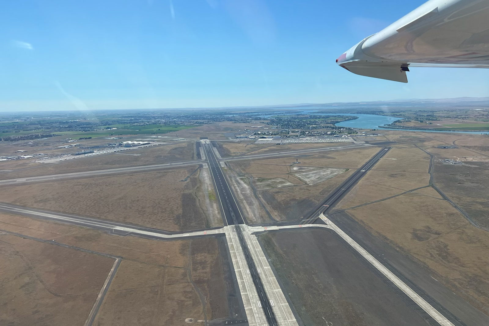
All told, we made our fuel stop at Grant County International Airport. Grant County has 5 runways, one of which is among the longest in the country (13000ft) and two of which are small enough to be confused for taxiways. We didn’t receive any instructions that were out of the ordinary, other than to land on Runway 18, a shorter, displaced runway.
While not imperative, having a co-pilot or additional crew member is helpful to identify a smaller runway, or more specifically, to distinguish it from other small runways (Runway 14, 09, etc.). After landing, it’s also helpful to use another person to help with taxiing and to verify the ground instructions, given you’re likely to be crossing or holding short of some major instructions.
Below is an aerial view of Grant County Airport to give you a better indication as to the layout.
Use the foreflight glide feature
It’s unclear how many people are aware of the Foreflight Glide Ring Feature (Garmin Pilot has a similar feature with their “Glide Range Ring.” Basically, the feature will allow you to input your best glide speed and ratio into the app and use this data to determine how far your aircraft will guide along its current course. Below is a good example of where and how we used this glide feature along our flight. If in an event we wanted to deviate slightly from following along our flight path or the interstate below, we could determine how far we could travel within glide distance of the interstate should we need to put the aircraft down.
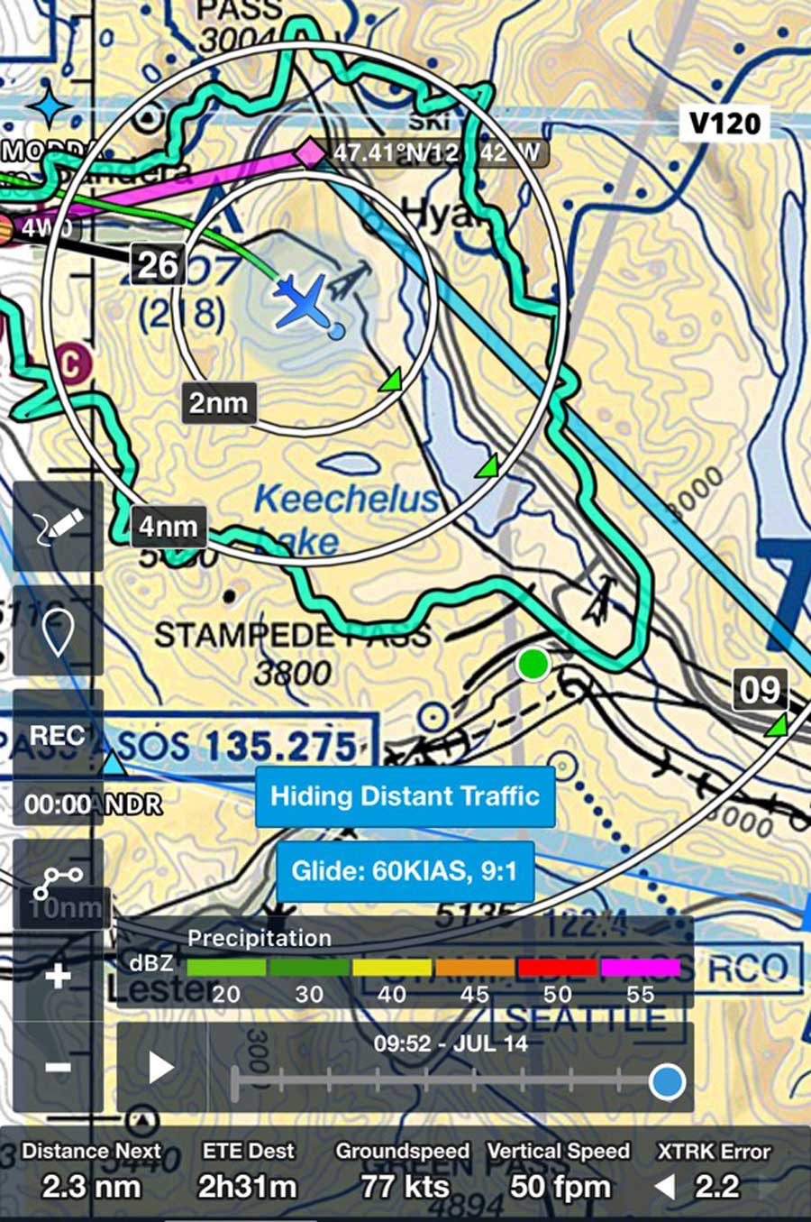
This is a great feature for pilots to utilize when flying VFR and can help give you peace of mind when considering adjusting a flight path or course for whatever reason. The glide feature is particularly handy when flying in the ICON A5, as bodies of water make for serviceable options for emergency landings, as well.
You can utilize this feature by going into “settings” on the Foreflight map and turning glide settings “on.”
It’s worth noting that while the ICON A5 has a full airplane parachute, it’s not meant to substitute for off-airport, emergency landings. Thus, being cognizant of your glide distance at all times is an important safety procedure to follow, making the guide feature a great tool to use.

Final Thoughts
The ICON A5 is an incredibly fun aircraft to fly. While the low cruise speed doesn’t make it perfect for every cross-country flight, the unique safety features and the incredible view create an experience unparalleled in general aviation and can make for some unforgettable cross country journeys. To say nothing of the peace of mind you have in flying long distances, knowing you have multiple outs during possible engine failure and in obstacle avoidance.
Regardless of which aircraft you fly your cross-country, hopefully some of these procedures offer a good refresher and can help you in your flight planning.

Paul is the Director of Marketing for ICON Aircraft. Before ICON, Paul was the Director of Video and Branded Content for Ranker, INC. and The Wrap. He was the host of Hulu's first original production, The Morning After, and co-developed Twitch.TV's first talk show, Game Talk Live. He is a private pilot based out of Pasadena, CA.